
How Building Information Modeling Can Help Preserve Historic Locations
Building Information Modeling (BIM) is a way to take, analyze, and store complex information regarding physical architecture. BIM is frequently used to simulate new developments, but it can also be used in the restoration of historic sites.
When historic sites are damaged, or simply falling apart due to age, scans and data can be taken for the next part of the restoration process. Here are a few of the ways in which Building Information Modeling can be used to the advantage of historic preservation.
Acquire Extraordinarily Accurate Building Data
Through highly accurate, LiDAR scanning, high resolution BIM information can be taken and stored. With this data, developers, architects, and historians will be able to identify areas in which they can restore and preserve historic locations. Using simulations, different options can be modeled. From there, it’s possible to identify the solutions that will be best suited for the project.
And it isn’t just preservation information that can be simulated. Continued wear on the historic location can also be simulated, so that developers know which areas need to be protected the most. Developers will even be able to see how the historic location might be influenced by other developments in the area, and consequently plan ahead.
When LiDAR scanning is used alongside photogrammetric imaging, even the texture and color of the buildings can be preserved. This can help with restoration attempts in the future. More data is always better; some restoration processes that aren’t available today could still be available in the future.
Get Information Without Physical Disruption
Physically walking through a historic location can cause damage to it, if even only slightly. But when drone technology is used to capture BIM, developers are able to work on the project without having physical access to it. This is critical. Otherwise, restoration might not be done properly because collecting information can’t be risked.
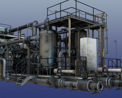
3D model of construction skid 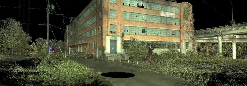
3D model of an abandoned hardware building 
BIM Modeling works for all types of projects
Scanning with laser technologies, on the other hand, gives the developer as much information as they need while still preserving the structural integrity of the site — and that means they have the ability to do significantly more accurate planning.
In the past, scanning from planes and helicopters would be the only option. But there’s a downside to this: scans from planes and helicopters are lower resolution. Planes have to fly too high, and helicopters can’t be flown with the same precision as a drone. And neither one can get inside a building!
Avoid Putting Physical Surveyors in Danger
Why is building information modeling important? It’s not just because it’s best for the buildings themselves; it’s also best for the people involved. Taking information through LiDAR and aerial scanning means that physical surveyors don’t need to put themselves in danger. Not only can a historic building be dangerous due to damage, but it can also be in a dangerous or in an inaccessible location.
With BIM, data can be taken before people need to physically step foot on site. BIM can be used to identify areas that are potentially dangerous before anyone needs to start work, and these areas can be marked clearly to be avoided.
Preserving Buildings in Simulations
Even if buildings themselves cannot be preserved, their data will live on forever. While the building may be able to be preserved and restored today, the buildings may fall in a hundred years, or even a thousand years. But the data that is taken regarding the building has the potential to be preserved forever.
Today, we have the technology available to rescue historic locations — and drones are an essential part of that process. With drone technology, exceptionally accurate building information modeling data can be saved, and in the future, that information can be used to restore everything to its original condition.
And, even if buildings are in good condition today, and not yet falling into disrepair, it’s a good idea to keep their information for the future. It’s possible that environmental changes could challenge these buildings in the future, or unexpected disasters such as earthquakes could strike. Buildings that have historic significance but are not currently undergoing restoration efforts are good candidates for this type of digital preservation.
Anyone who wants to preserve a building, whether historic or not, should consider the advantages of Building Information Modeling.