About Us

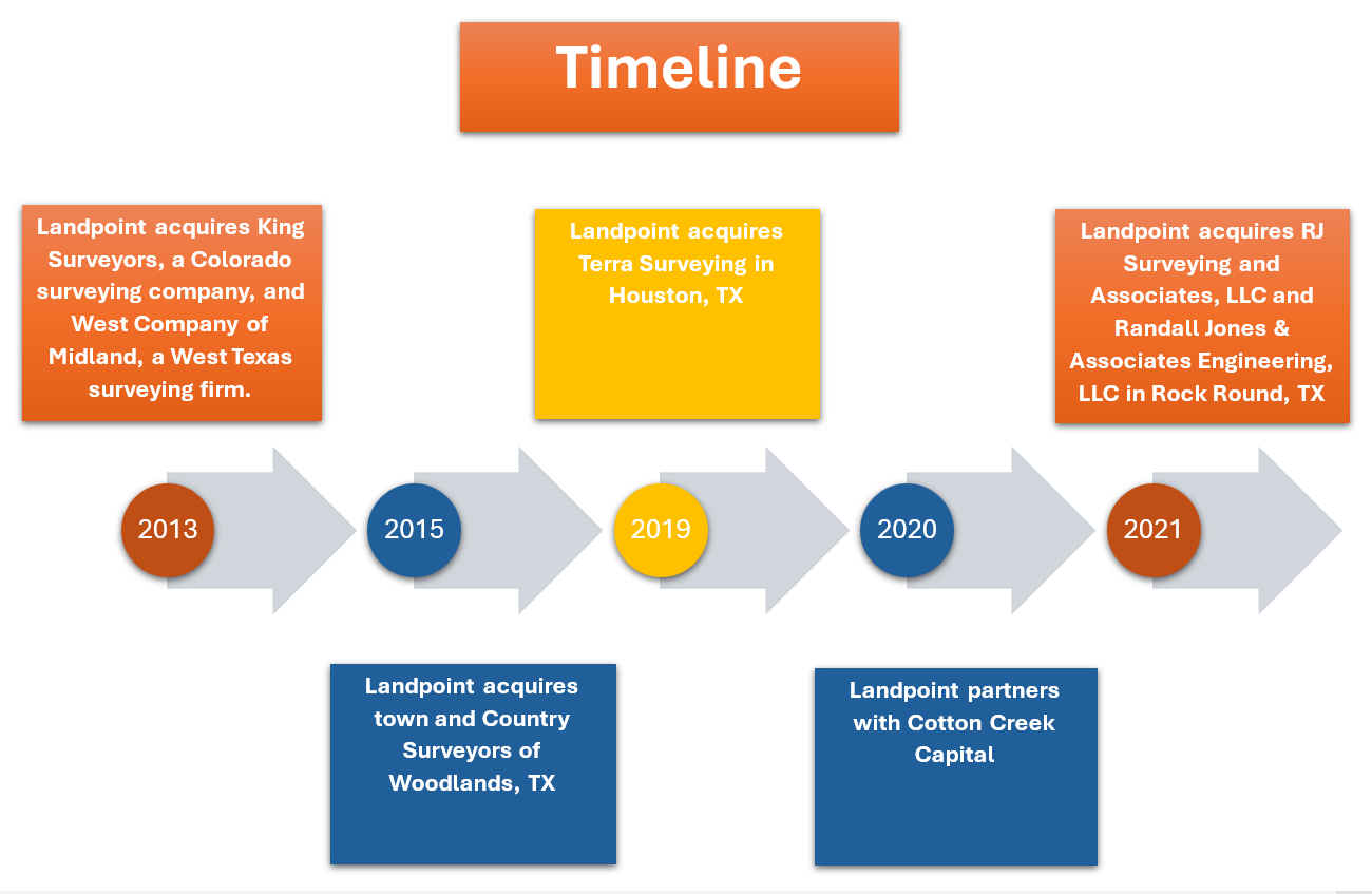
In 1984, Landpoint Surveys was founded by James L. Souter in Magnolia, Arkansas, with six employees and provided commercial land surveying. The company grew organically and executed strategic acquisitions, which expanded its geographic presence, customer base, and end-market mix. Today, Headquartered in Fort Worth, Texas, Landpoint has nine office locations and is licensed to operate in 27 states. Over the past four decades, Landpoint has covered projects of all sizes. Landpoint provides land surveying, aerial data collection, 3D laser scanning, and geographic information systems. The company serves a range of customers in market sectors, including energy, industrial, commercial, and utility, with notable strengths in serving large-scale, linear corridor projects, including oil & gas, electric transmission and distribution, water conveyance, and fiber optic networks. With over 40 years of archived data and meaningful operational infrastructure anchored by its propriety TrueAtlas technology, Landpoint efficiently and effectively delivers its services to a broad range of customers.

In 1984, Landpoint Surveys was founded by James L. Souter in Magnolia, Arkansas, with six employees and provided commercial land surveying. The company grew organically and executed strategic acquisitions, which expanded its geographic presence, customer base, and end-market mix. Today, Headquartered in Fort Worth, Texas, Landpoint has nine office locations and is licensed to operate in 27 states. Over the past four decades, Landpoint has covered projects of all sizes. Landpoint provides land surveying, aerial data collection, 3D laser scanning, and geographic information systems. The company serves a range of customers in market sectors, including energy, industrial, commercial, and utility, with notable strengths in serving large-scale, linear corridor projects, including oil & gas, electric transmission and distribution, water conveyance, and fiber optic networks. With over 40 years of archived data and meaningful operational infrastructure anchored by its propriety TrueAtlas technology, Landpoint efficiently and effectively delivers its services to a broad range of customers.
Growth
Landpoint is constantly seeking technology and growth-oriented firms to partner with nationwide.

Our Core Values
Do The Right Thing
Ethics
Quality
Integrity
Accountability
Respect
On Point With Safety
Empower
Recognize
Take Action
Succeed
Protect
Roll Up Your Sleeves
Drive
Collaborate
Innovate
Learn & Adapt
Complete The Task
Mission Statement
Our mission is to ensure a sustainable future through supporting power and infrastructure development.


Professional Land Surveying Licensing Map
Headquarters
North Central
4100 International Plaza,
Suite 240
Fort Worth, TX 76109
P: 800.348.5254
Texas Survey Firm: 10194220
Southeast Texas
1311 Broadfield Blvd.
Suite 275
Houston, TX 77084
P: 800.348.5254
Texas Survey Firm: 10194220
Louisiana Regional
5486 Airline Dr.
Bossier City, LA 71111
P: 318.226.0100
Louisiana Survey Firm: VF0000320
Colorado Regional
650 East Garden Dr.
Windsor, CO 80550
P: 970.686.5011
Colorado Survey Firm: 19931139879
North Texas
1431 Greenway Dr.
Unit 145
Irving, TX 75038
P: 800.348.5254
Texas Survey Firm: 10194220
Central Texas
2900 Jazz St.
Round Rock, TX 78664
P: 800.348.5254
Texas Survey Firm: 10194220
Arkansas Regional
100 North St.
Suite 16
Magnolia, AR 71753
P: 870.234.6384
Arkansas Survey Firm: 1591
West Texas
110 West Louisiana Ave.
Suite 110
Midland, TX 79701
P: 423.687.0865
Texas Survey Firm: 10194220
Arizona Regional
2501 West Behrend Dr.
Suite D-45
Phoenix, Arizona, 85027
P: 800.348.5254
Arizona Survey Firm: 24801-0
