Tips for Speeding up As-built Surveys
 For construction projects, anything that gets in the way of the project progressing according to schedule is a roadblock that must be removed as quickly as possible. However, when it comes to as-built surveys, project managers may feel trapped: they need these surveys to make sure their project proceeds safely and accurately, but at the same time, these surveys frequently take weeks to turn around, which often gets in the way of established project schedules.
Since project managers need these as-built surveys to make sure their project are proceeding according to plan, most of them assume that there is nothing they can do other than wait patiently for the surveyors to complete their work. However, two technologies are showing that this no longer has to be the case. Using these technologies, project managers can get the as-built documentation they need, without having to wait too long for them.
Read on to learn more about these two new technologies, and how you can apply them in your own construction projects.
3D Laser Scanning
With 3D laser scanning, land surveyors no longer have to travel from point to point on a job site collecting the information they need to complete their as-built surveys. Instead, they are able to gather all of the information they might need using high-tech laser scanning, which in turn allows them to build accurate 3D models that can give them all the detail they need to complete their work. As a result, a process that once took weeks can now be completed in a matter of a few days.
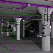
3D laser scanning, also referred to as LiDAR data collection, works by bouncing laser beams off the area that needs to be surveyed. Then, the scanner records a point everywhere the laser hits a surface. After the laser has scanned the entire job site, the result is a massive “point cloud” made up of millions of survey grade points. These points can then be connected to form an extremely detailed representation of the environment at the job site. Finally, this representation will be transformed into a 3D model, which is then used to support the work of the land surveyor. All of this happens much faster than a traditional as-built survey, which should make project managers everywhere very happy.
Project Management Suite
Unfortunately, actually completing the as-built survey is often just one factor in the construction delays they can cause. Turning your land surveys around quickly is great, but if you can’t put those surveys into the hands of the right people as quickly as possible, then it won’t translate into quicker, more efficient projects.
That’s where a good project management suite comes into the equation. A project management suite can provide a central hub for the entire project, giving all stakeholders a single place to go to upload and download vital project documents as needed.
With this technology in place, a project manager never has to worry about when the land surveyor will get around to sending in the completed as-built documentation. Instead, they can feel confident that they have the most recent and accurate versions of all documents, and that they will instantly be informed when the as-built surveys are ready. Then, they will be able to download and start utilizing those as-built surveys immediately, even if they are on the job site using a mobile device.
To learn more about these new technologies from Landpoint, and how they can help you get your as-built documentation sooner, contact us today.
Image Source: NOAA’s National Ocean Service

